Triangulation Stations by Joe Rosenberg
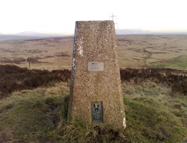
Technically known as “triangulation stations,” there are a series of markers spread out across Great Britain that most people refer to as “trig points.” They look simple, modest and utilitarian at a glance, but they mark the culmination of a centuries-long effort to archive something unprecedented: a complete topographical map of Great Britain.
With the Age of Exploration in Europe came an increased interest in colonization, but also an era of nation-state with standing armies, which required spatially accurate maps. Even as maps became more sophisticated, most of them were still limited in scope to specific towns or areas and many were also riddled with errors. The idea of a complete and accurate map of a country, which the world takes for granted today, was nowhere to be seen.
Finally, in 1744, the famous Cassini family of scientists in France created the first topographically accurate national map. The process was painstaking and piecemeal, and Britain wanted to do the same. Still, the whole-map approach they took wasn’t complete until 1853, 62 years after it was officially started. Then in the 1930s, they did a re-triangulation, to get more granular measurements, which took another 29 years.
The trig pillars still dotting the countryside are actually from the re-triangulation. They share an identical shape for the purposes of mounting the same surveying equipment from one point to the next. Today, around 6,200 remain and all of them (at least originally) were within sight of at least two others, spread across the entire island.
So far, only one person has claimed to visit them all, a 59-year-old man named Rob Woodall. He is part of a small but flourishing community of people called “trig-baggers” who like to visit and catalog trig points. It took him over ten years to accomplish his goal, in part because some of the pillars are in really remote places or located on military or private property. Some have been destroyed or moved, too, over time, for instance along coastlines that have eroded this past century.
Woodall is also quick to note that these more visible markers are just the tip of an infrastructural iceberg. Surveying markers and marks are all around us, including less obvious ones like benchmarks or cut marks. Most cut marks have the same symbol, made up of three converging lines, called the King’s Broad Arrow. Once you know to look out for it, you can start to see these little arrows everywhere in the UK, or their analogues in other countries around the world.


Comments (20)
Share
can you link to inception island?
Where is Inception Island?
I just got Google Maps to approve a geotag for Inception Island!
https://www.google.com/maps/place/Inception+Island/@69.7924795,-108.2432585,16.5z/data=!4m5!3m4!1s0x5191f341dbb780f1:0x7e4d0e9c9f107f1a!8m2!3d69.7924404!4d-108.2410965?hl=en-US
The discussion of graffiti on trip points made me think of the Cofiwch Dryweryn phenomenon. It’s a slogan meaning ‘Remember Tryweryn’ that started appearing all over wales (on Trig Points and elsewhere) as a low key Welsh nationalist movement, recalling the flooding of a Welsh valley to provide water largely for English towns. It began in the 1960s, but is still quite a common phenomenon. Might be an interesting subject for a show some time.
Link to Lauren’s work?
HI, can you please post a picture of the location of “inception Island” ????
As a long time Ingress player, 99pi has been something of an inspiration (I once used the “always read the plaque” shirt as neutral camouflage during a large scale Ingress battle, where participants often wear faction colors!)
Since you’re in Oakland, you should probably visit Niantic’s offices in SF (you probably already know what the company name is from…)
A show about Ingress itself would be worthwhile. It draws thousands of players worldwide to special events and is played daily by many more. A good time to meet some is every first Saturday of the month, when there is an official gathering in cities all over the world.
Great episode as usual. It reminded me of my childhood: I used to go to summer camp on Star island in Cass Lake in northern Minnesota (Unistar!!) – I have no way to verify this but the camp used to say the lake located on the island, Lake Windigo, was the largest lake on an island on a lake in the US. Cass Lake is also just downstream from and was once named the head waters for the Mississippi River. A beautiful place to visit in spite of the millions of mayflies that descend on the lake in early summer.
There is another inception island in the Philippines.
– Vulcan Point Island is inside…
– Crater Lake which is inside…
– The Taal volcano and happens to be an island inside…
– Taal Lake which is inside…
– Luzon Island, the largest island in the Philippines.
Vulcan Point Island
San Nicolas, Philippines
https://maps.app.goo.gl/cVbsap1scm2CPM1D7
This Pokemon song is so awesome :)
Ah, i wanted to know: what’s the title? I don’t remember it from the first game.
I have to admit, that I had a fleeting hope that one of the stories in this episode would be about people who draw their own maps and invent their own worlds for their writing or for D&D. Even with the limited exposure that I’ve achieved, it blows me away the lengths that some people go to to invent constructed languages or fictional worlds detailed down to the plate tectonics.
All the same, my own efforts in the future will go a little further to include enclaves and exclaves as well as triangulation stations in my made up maps.
Very good pod, Kurt. To the quirks of the enclaves and exclaves, I would add Bir Tarwil – the place in the middle east that is not in any country ! https://www.sporcle.com/blog/2017/09/a-history-of-bir-tawil/
I have always been fascinated by the pieces of states that are separated from their home state by the meandering history of the Mississippi River (and other rivers, I’m sure). Look closely at a Google map of Arkansas’ southeastern border, as just one example. Pieces of Arkansas are now on the Mississippi State side of the river, and vice versa. When this happens, do states ever renegotiate their boundaries?
What about Ryan Island mentioned on NPR the other day? They said it was the largest island in the largest lake on the largest island in the largest lake in the world. https://goo.gl/maps/7Uo2V6GfFVEudSZ37
When you first mentioned the “Inception Island” in Canada I thought you were talking about the one in Newfoundland!
https://goo.gl/maps/owCsdczTuUaiGmQG6
Great episode as always!
“They were fairly sure where Greenwich observatory was” (approx quote. Longitude is defined by Greenwich observatory!!!!
Would love to hear a Part 2 on the bits of soil designated as foreign territory for political reasons: e.g. embassies, military cemeteries, and this tiny piece of Holland I’ve always been charmed by:
https://www.canadiangeographic.ca/article/ottawa-maternity-ward-became-international-territory-birth-royal
Another great episode. Obviously, I’m a few months behind.
To add to the Inception Island theme, here is a trivia question from my backpacking days: What is the largest island, on the largest lake, on the largest island, on the largest freshwater lake in the world?
Ryan island: https://www.google.com/maps/place/Ryan+Island/@48.0098966,-88.7796652,15z/data=!3m1!4b1!4m5!3m4!1s0x4d598399fadfc645:0x5b3f085da13b222d!8m2!3d48.0098831!4d-88.7709104
When it comes to exclaves, Steinstücken should be mentioned. An exclave of West Berlin, which itself was an exclave in the GDR. Funny how after many years of negotiation pieces of land were traded so a connection between the two could be built. And what implications a bridge would bring with it.
https://en.wikipedia.org/wiki/Steinst%C3%BCcken?wprov=sfla1