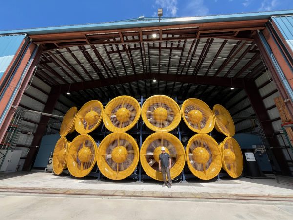
On the campus of Florida International University, in Miami, there’s a place ominously named “The Extreme Events Institute.” They map the risk of storm surge for the whole Caribbean, and study how the public perceives the threats from natural disasters. They’re also home to the International Hurricane Research Center. Their hangar houses a dozen giant yellow fans, stacked in two rows of six. Each fan is six feet in diameter. They were originally made for ventilating mining shafts, but engineers here have figured out how to get them to make hurricane-strength winds. This is a lab where researchers are figuring out how we can make our homes and infrastructure survive hurricanes better, especially at a time when more intense storms are going to be more frequent.
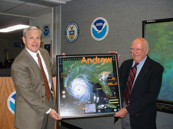
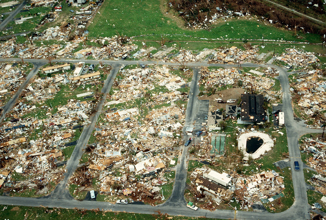
Hurricane Andrew made landfall in 1992, just south of downtown Miami. It had sustained winds of 165 miles per hour, destroying at least 50,000 homes – ripping some of them right off their foundations. It was the costliest disaster in US history at the time. Meteorologists designated Hurricane Andrew a “Category 5” storm. It’s the highest classification according to the scale used for measurement, “The Saffir Simpson Hurricane Wind Scale.” For 50 years, the Saffir-Simpson Scale has been the language we all rely on to understand what kind of risk a hurricane poses. We’re primed to hear the category vocabulary in emergencies.

The scale has also transcended hurricanes. It’s been adapted for various situations because it’s a clear, easy shorthand for damage, and provides a snapshot of probable impact. Five decades on, however, there are doubts now about whether the Saffir Simpson scale is telling us enough in that snapshot, and whether it still serves this changing world we live in. The chaotic nature of hurricanes makes them tricky to characterize, even in an age of satellites and radar. They’re capricious; they can get stronger or weaker and change direction quickly. No two are the same, and even a single hurricane isn’t uniform all the way around; they have a stronger side and a weaker one.
Early Meteorology
Modern forecasting didn’t exist until the mid-19th century. Before that, the Taino (who were among the original inhabitants of the Caribbean) taught colonizers how to tell one was coming. It wasn’t until the 1870s that observers began to accurately predict where a hurricane was coming from and going to, and how destructive it might be when it got there.
That big leap forward came from a Jesuit named Father Benito Viñes working out of a coastal observatory in Havana, Cuba. Known also as the Hurricane Priest, he watched clouds and had plenty of equipment – even some he invented himself, which he used as clues to predict where bad weather was coming from and headed to. Father Viñes set up a telegraph network for hurricane news from across the Caribbean. Even after he died in 1893, Cuba’s forecasts were more accurate compared to the ones from other countries.
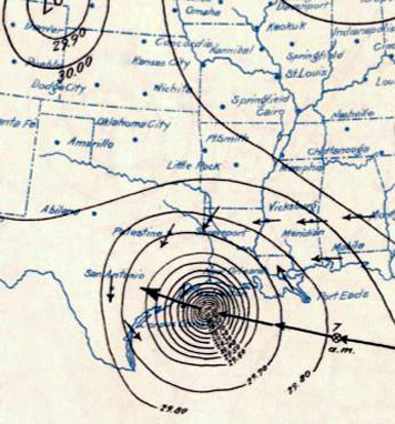
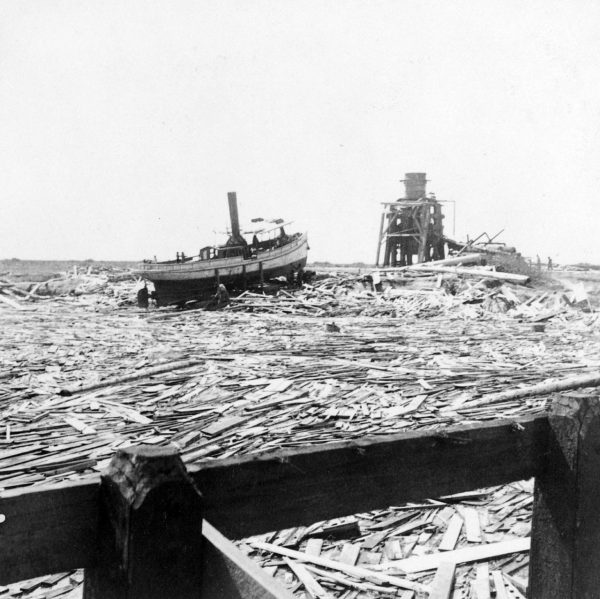
In contrast, the US system was sluggish and conservative. Meteorologists around the country had to wire their reports to Washington DC, where the central office would decide what was real and worth sharing. Warnings went out slowly, if at all, and the public was frequently caught off-guard when big storms arrived. Then, things got worse. In 1898, at the end of the Spanish American War, the US took temporary control of Cuba and its warning systems. Instead of cooperating with their colleagues in the Caribbean, the Weather Bureau restricted access to telegraph cables and promoted their own warning systems instead. They paid the price almost immediately. In September 1900, Cuban meteorologists warned of a storm that was going to intensify, turn into a hurricane, and head to the Gulf of Mexico. Galveston’s population was 38,000 people at the time, and as many as 8,000 died.
Hurricane Hunters
Decades later, two airmen – also in Galveston – made a bet to show how tough their planes were and deliberately flew it into a hurricane. When they landed, a meteorologist from the base asked to go up next, and it caught on. By the early 1950s these pilots and scientists formed a cadre called “Hurricane Hunters.” They would fly directly into swirling storms, which gave them an unprecedented ability to observe hurricanes close up. But there was still no way to communicate that forecast clearly and concisely to the public.
In 1969, a hurricane named Camille stalled in the Gulf of Mexico. The National Hurricane Center put out alerts about Camille which went beyond the simplistic language of existing warning systems. But those meteorologists ended up giving the public too much information. Camille’s wind speeds are now thought to have been 175 miles per hour when it made landfall. The winds were so strong that they destroyed the equipment used to record them. Today, we would call Camille a Category 5 hurricane. It killed 256 people, reduced homes to debris, and is one of only four Category 5 hurricanes to have ever made landfall in the US.
The Saffir Simpson Scale
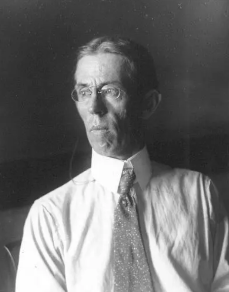
In the wake of Hurricane Camille’s devastation in 1969, it was clear that the world needed a system for rating storms that would help people understand the threat, and how to respond. At the same time, a structural engineer in Miami-Dade county named Herbert Saffir was developing a hurricane scale as part of a project for the United Nations, and it was based on structural damage from wind. It rated hurricanes 1 through 5 based on wind speeds, and described what you would expect from each level of intensity.
In 1974, “The Saffir-Simpson Hurricane Damage Scale” was first published in a scientific journal, and the National Hurricane Center started using it for the public. The scale explains what each of the five categories would entail. A “Category 1” would likely damage mobile homes that aren’t anchored to the ground, for example. In a 2, there would be some widespread power outages. A “Category 3” would cause devastating damage, including trees getting uprooted or snapped, and power outages for weeks. Category 4 or above was catastrophic.

Category 5’s would bring power outages for months, with the tops of industrial buildings and whole structures getting blown away.
Hurricane Dorian sat on top of the Bahamas in 2019, dumping rain for 48 hours. Although Dorian was technically designated a Category 5, everyone who saw it thought it was way bigger. Its intensity introduced a new question regarding how we talk and think about hurricanes.
We’re Going to Need A Bigger Scale…
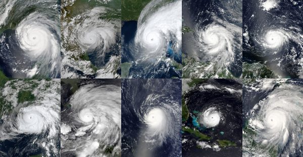
Scientists say that climate change means stronger storms are going to be more frequent, and that they’re likely to intensify a lot more quickly. That’s true in the Pacific, where hurricanes are called typhoons or super typhoons, and also true of hurricanes in the Atlantic. In the past 50 years, the US has been hit by ten hurricanes that were Category 4 or 5. Seven of those giant storms have happened since 2017. The worsening trend is why some meteorologists suggest expanding the Saffir Simpson Scale to include a Category 6.
Climate change has forced scientists to make other adjustments to their extreme weather warning systems. The Australian Bureau of Meteorology added two new colors, pink and purple, to their maps to convey record-breaking heat. A Category 6 would expand our vocabulary for this greater risk, and drive home the urgency of climate change. But the National Hurricane Center, which administers the scale and is in charge of categorizing hurricanes, isn’t keen on adding a 6 to Saffir-Simpson. There’s fear in the scientific community that expanding it would do more harm than good. It is to do with people’s response when faced with risk, as several do not evacuate for a Category 4 or 5.
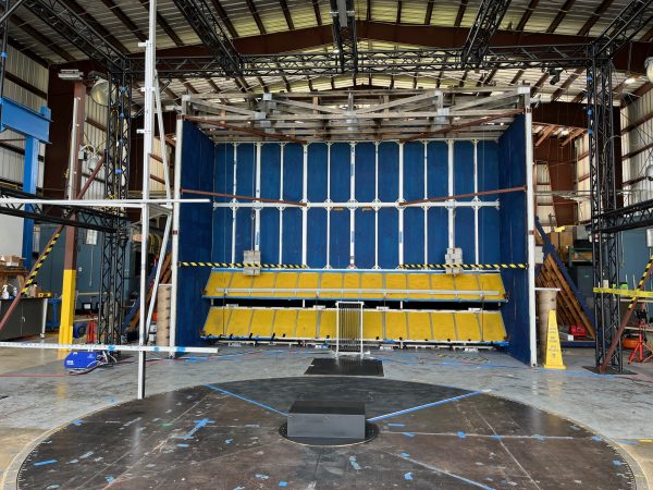
At the Wall of Wind, a big government grant is being used to figure out how to build a bigger, stocked lab – one that will go up to 200 miles per hour and have a big water tank to simulate storm surge and waves. The aim is to simulate the whole hurricane, not just the wind aspect, in order to figure out how buildings and infrastructure could withstand stronger storms. That type of facility would add to the Saffir Simpson scale, which does not take into account how much rainfall a hurricane might cause, or the expected storm surge. There are a lot of complicating factors in the relationship between wind speeds and storm surge, like the angle of approach to the coast, or what the continental shelf is like there. This is the reason the National Hurricane Center stripped water out of the scale in 2010.
The warming climate is going to bring an increased number of storms. Forecasters say 2024 will be a “hyperactive” hurricane season – with an abnormally high number of storms hitting the North Atlantic. The tools we have for communicating the risk are far from perfect, and these shortcomings must be addressed. As storms get more intense and more frequent, the need of the hour is a system that rises to the occasion, not just another word for catastrophe.

Leave a Comment
Share