As cities evolve, architecture often fills in abandoned routes designed for cars and trains. Still, the remnants of old voids can persist in the shapes of new structures. Slicing against the grain of the city, these buildings are especially noticeable when they defy a rigid grid. The cuts they follow are rendered solid, resulting in a kind of architectural scar tissue as if the built environment were healing around old wounds.
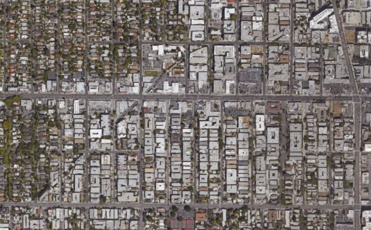
Like pieces of a giant puzzle, the resulting patterns can be hard to spot from a street-level perspective. Zooming out on digital maps, one can sometimes trace the effects along entire neighborhoods.
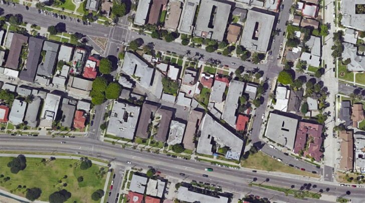
Zooming back in, the oddities of a single block become apparent. Individual buildings may feature an unusual angle here or there but bigger cross-block trajectories are evident as well.
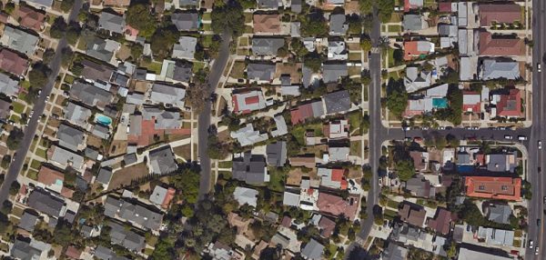
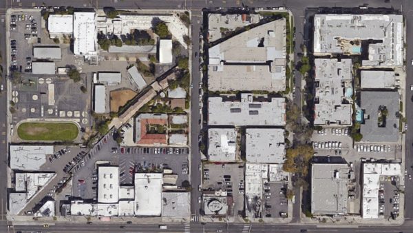
In some places, the walls of otherwise rectilinear structures end up oriented along these historic lines or curves. In other cases, entire buildings end up aligned with past passageways, from their foundations to their rooftops, like the houses above that go against the grain of their neighborhood. “The notion that every city has these deeper wounds and removals that nonetheless never disappear is just incredible to me,” writes Geoff Manaugh of L.A.’s ghost streets. “You cut something out—and it becomes a building a generation later. You remove an entire street—and it becomes someone’s living room.”
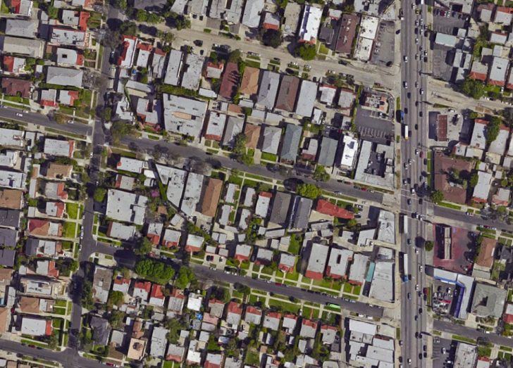
And it is not just architecture that is shaped by re-purposed routes — bits of leftover streets, parking lots and civic infrastructure can end up oriented in ways that reveal a forgotten thoroughfare.
At street level, a single strange angle can signal something larger. Consider the pair of embeds above and below. Above: the facade of a church in San Francisco and its obtusely-angled side. Below: that same church (lower left) as part of a larger scar across the urban fabric.
On the flip side of this phenomenon are what one Toronto area resident calls “scars of anticipation.” Metafilter user Sys Rq describes grand plans from the 1970s that wound up “half-finished and long since abandoned, for the seamless suburbanization and regionalization of a once-standalone town that has since glommed into the Greater Toronto Area.” As a result of anticipated expansion: “We have a couple major thoroughfares that just stop at an obstacle — ravine, creek, railroad — and continue on the other side without a link.”
There are also places where voids remain voids but their uses have evolved, adding functions as parks or walking paths. Above: a greenway follows the open route of a city water pipe in Hamilton, Ontario.
The result of all of this is a sort of urban palimpsest, a term typically referring to a written work (like a scroll or canvas) that is erased and overwritten but on which pieces of an older work can still be seen.
Like sectional artifacts of demolished buildings or products of adaptive reuse, urban architectural scars likewise reveal underlying layers of history (above: infill along an old industrial railway route in Chicago).
You can find more examples of scarchitecture on Bldgblog, Metafilter and Greater Greater Washington, but also keep an eye out for the phenomenon as you walk around your own neighborhood (or surf Google Maps) — a lone curved or angled wall or lot may well represent a small piece of a much larger puzzle.




Comments (14)
Share
Not sure if it’s one of the unmarked ones but the remnants of an old street car track can be seen from the liquor store/pizza spot parking lot at Hollywood and La Brea in Los Angeles
If you look closely at at New York City’s East Village on your satellite map of choice you can see remnants of the de-mapped Stuyvesant St which ran from St Marks Place to the old Stuyvesant Farm on what is now 14th Street. The road still exists for one block but if you follow the diagonal to the northeast you can see one or two back buildings which used to face the roadway
There’s one of these in Mountain View, CA running from Central Expressway to Middlefield Road across Shoreline. I’ve never thought about a word for it before, but it’s nice to know what to call this sort of feature. You can see it in this Google Maps screenshot: http://imgur.com/37J4tSq
That scar across Mountain View (and other parts of the South Bay) posted by Drew Bolechl is the path of the Hetch Hetchy Aqueduct. While it has a similar form to the “Scarchitecture” of abandoned and redeveloped right-of-ways, it is in fact an active easement owned by the San Francisco Public Utilities Commission. The SFPUC limits development atop their aqueduct so there’s never buildings. Some parts are green-belt or parking lots or just fenced off undeveloped lots.
Never knew these had a name, but I’ve always found them interesting. Two more from the Chicago Area:
Old Town Triangle retains its name, but is no longer a triangle since its western border, Ogden Ave. was closed in the 60’s
https://www.google.com/maps/place/Old+Town+Triangle,+Chicago,+IL/@41.9147807,-87.6419682,1589m/data=!3m2!1e3!4b1!4m5!3m4!1s0x880fd33fe5617abb:0x8d05da9de5ac8be!8m2!3d41.9136739!4d-87.6377593
Abandoned C&NW Route that cuts through Evanston:
https://www.google.com/maps/@42.046219,-87.682273,5484m/data=!3m1!1e3
My hometown of Peterborough, Ontario. a little north of Toronto, has a good example of one of those scars of anticipation. There was a planned north\south arterial street that had land set aside for it, but only two (unconnected) sections were ever built, leaving the city with stretches of green space on either side. While I’m no fan of excessive roadbuilding, it has meant that the city is much easier to navigate east-west than north-south, now.
Here’s a Google Maps link centred on the “middle” section of the road: https://www.google.ca/maps/@44.3007112,-78.3437049,3244m/data=!3m1!1e3?hl=en
It’s unfortunate there’s a rush to infill these odd shaped properties as many of the abandoned lines would likely be useful to build new streetcar lines or urban pathways for walking & cycling. Still, fascinating to see and put a name to.
This is even more common in European cities were old structures like city walls dominate the architecture for centuries, sometimes millennia. Often even Roman street lines exist to this day, while the houses around them were torn down, burnt, rebuilt over and over again.
Scarchitecture should not be confused with Sklarchitecture:
http://www.sklarchitect1.com/
They are very different things.
Seattle has some dreadful examples of streets that were cut through neighborhoods to facilitate highway-like floods of cars, but have never recovered. No infill buildings, no street presence, no nothing. Examples: the extension of Boren Avenue from Broadway to Rainier Ave S, or Green Lake Way N, one of several diagonals cut in the early 30s to funnel cars to and from Aurora Avenue N. It’s almost 90 years later and these are still vast dead zones in the city, but no one notices because Seattle residents assume that everything is about the car.
Outside cities, I read that in England, archaeologists use field boundaries existing today to identify roads and trackways that in some cases go back before the arrival of the Romans.
There’s a lot of this in LA. Pacific Electric rights of way are visible all over. I lived near a section of one in Long Beach and there’s another one just north of me in Bellflower with the station preserved, the route repurposed as a bike trail (https://www.traillink.com/trail/bellflower-bike-trail/). Also a greenbelt in Long Beach (http://www.longbeach.gov/park/park-and-facilities/directory/pacific-electric-greenbelt/), the one I lived on.
Very cool! I grew up in the shadow of the Little Miami Railway. In most of my area, the railway has been converted to multi-use bikepaths. The bikepaths follow the same route and use all the old bridges. If you know what to look for, you can see lot’s of old infrastructure like water towers, telephone poles that ran alongside the railroad, old pipes that I’m honestly not sure what were for. An old train station was long ago converted to a bar which is sortoff a local legend because it used to have a monkey that would take cigarettes and shots from patrons until peta took him away. Not far from that, there’s an old cartridge factory that’s in the process of being converted to apartments. Out of curiosity, I’ve traced the old railway through more densely populated areas in the past and noticed exactly what they’ve shown here. In some places, the rail is still there and abandoned, in others, it’s still in use, and in yet other areas, the cities have found clever new uses for it!
Slightly related, there are some old farmhouses in my area that we’re built before the 50s. New subdivisions have been built around them and the houses have largely been upkept. You’d never notice the houses, but I’ve pulled old photos from USGS. Once you see the houses there, it’s easy to spot the old ones. The back yard of the house I grew up in used to flood every time we had a decent rain. Sure enough, USGS photos show a lake, in my backyard, long before the house was there.
I’ve spent hours hiking in some of these areas, looking at all the cool old stuff. While it seems silly, I’ve got a strange attachment to the history of this location. It’s one of a handful of reasons I’ve opted not to move for other opportunities.
In Berkeley CA a long-gone streetcar line left houses at odd angles in its wake in this view: https://goo.gl/maps/WjHNDcrnUaKhPjv2A