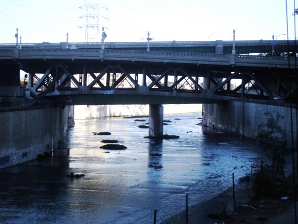
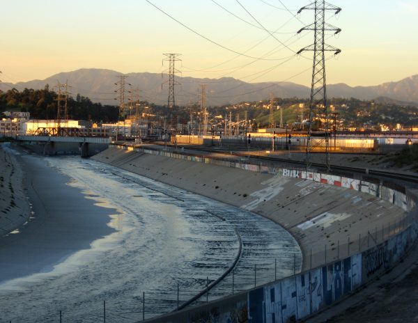
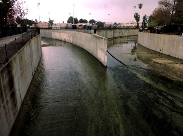
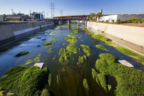
When you hear the word “river,” you probably picture a majestic body of water flowing through a natural habitat. Well, the LA River looks nothing like that. Most people who see it probably mistake it for a giant storm drain. It’s a deep trapezoidal channel with steep concrete walls, and a flat concrete bottom. The LA River is a surreal place to be, which has made it a great location to have edgy photoshoots or film movies like Grease or Terminator 2.
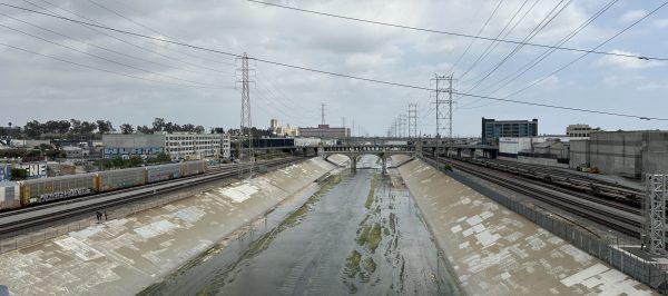
Los Angeles was founded around this river. But decades ago it was confined in concrete so that, for better or worse, the city could become the sprawling metropolis that it is today. All these years later the county is still grappling with the consequences of those actions.
The Peculiar River
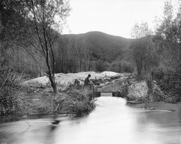
Before the river was encased in a narrow concrete passageway, it wandered freely throughout the Los Angeles basin. After heavy rains, the LA River would swell from a trickle into a full blown river, but with no fixed course. Sometimes when the river flooded, it would cut new pathways, turning different parts of the LA basin into a tapestry of wetlands and inland seas
All of this untethered water had a huge impact on the entire ecosystem of Los Angeles. People today look at LA and think it’s a desert because it’s so dry. But the climate is actually closer to the kind of Mediterranean weather you might find in Spain or Portugal. The river supported dense forests, marshlands, and enormous biodiversity.
“The river just not did did not just affect the corridor that it runs in. It affected the whole landscape,” says Matthew Teutimez, tribal biologist for the Gabrieleño Band of Mission Indians, Kizh Nation. Teutimez says the Kizh built their lives around the water provided by the LA River. “Now the la River, the ancient name for it is, wenot, which means the “life giver.” That pretty much explains it all in terms of the capacity of what this river provided.”
Even in its original, natural state, the LA River was very boom or bust. During the rainy season the river would flood wide swaths of the LA basin. But during the dry season – which in LA is most of the year – most of the rushing surface water would shrink to a shallow stream. Despite these patterns of flooding and drought, the river was more than enough to support the indigenous communities of the LA basin.
That is until the arrival of European colonizers. Los Angeles fell under the control of Spain, then Mexico, then finally the United States. To settlers from the east coast, the LA River (which seemed both too wet and too dry) was baffling. “Yankee rivers earned their keep. Yankee rivers are rivers where you can float barges and move goods and commerce and people […] so it was a very frustrating river for people who came with these industrial sensibilities to look at and to depend on,” says Patt Morrison, author of Río L.A.: Tales From the Los Angeles River.
When California gained statehood in 1850, the population of Los Angeles absolutely exploded. The city grew from just under 2,000.. to 100,000 people in only 50 years. This growing population began depleting the river and its groundwater. To the point that by the turn of the 20th century, the LA River was completely dry.
To make room for the people and industries of a booming new city, developers built closer and closer to the dried up banks of the river. But this shortsighted development backfired because Los Angeles was built to flood.
Floods, Floods, and More Floods
Although the Los Angeles River was at this point mostly dry in the early 20th century, it was only a matter of time before Los Angeles had another big rainy season. “The principal city of Los Angeles, sits in a bowl that’s surrounded by the ocean and then by mountains and hills and all of the rains that come to those areas over the course of a winter have nowhere to go except down, and we are down,” says Patt Morrison. What makes the LA River’s flood path especially dangerous is just how quickly the water can move once it gets going. The watershed begins high up in the Santa Susana Mountains, the San Gabriel Mountains, and the San Fernando Valley and drops to a very low altitude in the blink of an eye.
In 1914 Los Angeles was hit with a major flood that caused so much damage that there was a public outcry for the city to address its flooding problems. Twenty years later in 1934 it happened again, only much worse. In the last week of December in 1933, Los Angeles was slammed with a heavy winter storm, and on New Years Day, the banks of the LA River swelled beyond their capacity. This second flood gained national attention (including a Woody Guthrie song) and prompted the federal government to step in. In 1936 Congress pass a law that gave the US Army Corp of Engineers authority over the LA River to build flood control measures.
But it was a third flood just a couple of years later that would lead to the river’s downfall. March 2, 1938 is to this day the wettest day on record for Los Angeles and led to the most devastating flood in the city’s history. In current day value the flood caused about 1.7 billion dollars worth of damage and an estimated 115 people were killed.
That was the final straw. Los Angeles had had enough. Los Angeles residents were tired of living under the constant threat of flood. City leaders also hated the fact that the expanse of the river’s floodplain took precious real estate off the market. So the city decided to take its most drastic step yet: it would pave its natural river.
Straitjacketing the River
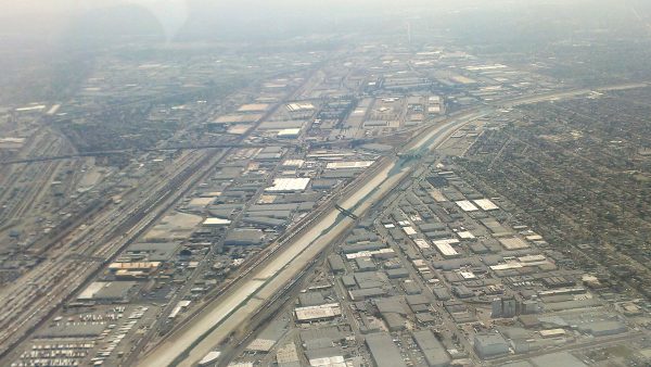
The plan was to carve out a 51 mile set pathway and seal the river into place with concrete. The river’s sole purpose would be to funnel stormwater out to the sea as quickly and efficiently as possible. Taking this enormous watershed and packing it into a narrow concrete channel was an incredibly ambitious plan. But the United States at the time was in the depths of the Great Depression and when the Army Corps of Engineers was tasked with this channelization project it put 17,000 people to work.
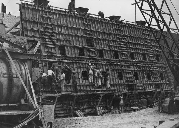
Over the next 21 years, the Army Corps of Engineers moved twenty million cubic yards of earth, poured 2 million cubic yards of concrete, and placed nearly 150 thousand pounds of reinforced steel. “It remains the largest public works project west of the Mississippi,” says Jenny Price, a writer and public artist who used to give tours of the LA River. By 1960 the river had been completely transformed and then barricaded behind chain link fencing.
The channelization of the river was an extreme, even violent approach to flood control. But in a way, the concrete did what city leaders at the time wanted it to do. The county, so far, has not experienced a flood as devastating as the one in 1938. With the river fastened into place, Los Angeles was also able to urbanize at a breakneck speed. Now nearly one million people live within a mile of the river
But when Los Angeles traded its natural river for real estate, it created a slew of other environmental and social problems. Although the region is plagued by drought, by turning the river into essentially a flood control channel, Los Angeles County has shut off an important water source capable of replenishing its soil with nutrients and aquifers with rain water while also importing a vast majority of its fresh water from other watersheds. The concrete exacerbating cultural and economic divisions within the county.
The Invisible River
After the LA River was paved, it remained mostly ignored for decades. Even though it ran straight through the heart of Los Angeles County, people forgot it was there. For all intents and purposes, the river was just another piece of infrastructure. But in the 1980s, twenty plus years after the LA River was paved, something slowly began to change. Some people in Los Angeles started looking at the river a little differently. They began to question whether the river had to be like this.
The first and loudest of these people was an artist named Lewis MacAdams. According to the Los Angeles legend, in 1986 MacAdams and a group of friends cut a hole in the fence surrounding the LA River and went in. From that moment on MacAdams was determined to be an advocate for the LA River. He founded an organization called Friends of the Los Angeles River which was made up of other artists and architects. They made it their mission to get Angelenos and policymakers to start thinking and caring about their river again.
Eventually, the LA River went from being a niche artistic project to a mainstream one. Other groups and individuals started wondering if it were possible to restore some of the natural habitat along its concrete banks, or if the river could be part of a solution to the region’s constant drought, or if the river could create a public greenspace for Los Angeles.
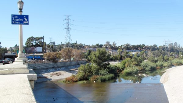
After years and years of grassroots activism, by the early 2000’s the river was still trapped in concrete, but a few pocket parks had sprung up along the river. Although the river still looked very similar to its lowest point, things had gotten better and there were those in Los Angeles who cared about its fate.
To Boat, or Not to Boat? That is the Question
In 2006, right in the middle of the Los Angeles River’s comeback, a Supreme Court decision called Rapanos vs. United States pulled the emergency break on all that positive momentum. The case challenged protections granted by the Clean Water Act. The Clean Water Act states that it’s illegal to discharge any pollutant into quote “navigable” waters. What this case in particular argued was that wetlands and ephemeral rivers – like the LA River – didn’t count as “navigable” waters because they dried out for a lot of the year.
In 2008 the Army Corps of Engineers ruled that Of the 51 miles of river, less than four were navigable and therefore worthy of protection. Taking away the its Clean Water protections was basically accepting that the LA River would never be more than a flood control channel, setting back decades of forward-thinking momentum achieved by environmentalists.
Luckily, a whistleblower within the Army Corps of Engineers itself sprung into action. At the time, Heather Wylie was working as a biologist within the Army Corps of Engineers. Wylie leaked the information to a number of top environmental lawyers, as well as the House Oversight Committee. At the same time she was also furiously researching to find any proof that the river actually was “traditional navigable,” which led her to a Youtube video posted by a man named George Wolfe.
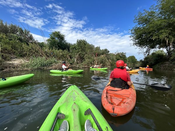
It’s a short comedy video that Wolfe and a friend posted that featured a man in a suit, trapped in his car in standstill LA traffic. Out of frustration, he gets out of his car, hops in a kayak, and rafts down the LA River. When Heather Wylie clicked on that Youtube link she realized that this could be a way to prove that the LA River was, in fact, navigable.
Wolfe signed on to help. He assembled a group of a couple dozen kayakers, including Wylie, for a kayaking trip down all 51 miles of the river. They scheduled the trip for the dead of summer when the water runs at its lowest, just to prove that even under the harshest conditions it was possible. The trip took three days as they kayaked through the San Fernando Valley, around the movie studios, through Downtown LA, out to that final open stretch out to Queensway Bay in Long Beach. The team collected data and measurements during the trip, and wrote up their experience into a big report to submit to the EPA. It took two years but in 2010 the EPA stepped in and overruled the Army Corps of Engineers, declaring that all 51 miles of the LA River were navigable and therefore would keep all of its Clean Water Act protections.
The kayaking stunt helped to restore the river’s environmental protections and renewed a lot of interest in it, but river advocates say there is still a lot to be done when it comes to revitalization. The river itself passes through 17 different cities, as well as county, and federal jurisdiction. It also impacts a number of different communities so there are a lot of conflicting ideas for how to make the river a better place for Angelenos in an equitable and responsible way. Although there has been disagreement on what revitalization should look like or how we’ll get there, there is one thing that all of these agencies, and organizations, and advocacy groups, and individuals, and kayakers can agree on: the LA River is a river.


Leave a Comment
Share