As Polish-American scientist and philosopher Alfred Korzybski observed in the early 1900s: “the map is not the territory it represents, but, if correct, it has a similar structure to the territory, which accounts for its usefulness.” The point, in part, is that maps are representations of places rather than substitutes for reality, which has various physical and philosophical implications. At the same time, though, the flow of data from places to maps is not always one-directional — maps may be representations of reality, but they can shape reality, too.
The Third-Order Enclave by Kurt Kohlstedt
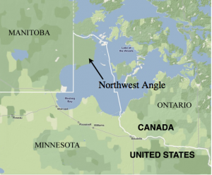 Maps of the United States feature a small but noticeable bump up in the middle — a spot where Minnesota seems to protrude into Canada. This unusual location, known as the Northwest Angle (or simply: the Angle) is technically accessible by boat, but is what’s known as a “practical exclave” — practically speaking, a normal person who wants to get there overland by car or otherwise has to go through Canada, stopping at shacks to video call a border agent or using an app to check in on their way in and back out. So it’s not impossible, but it takes some extra work.
Exclaves and enclaves can get confusing, in part because there is some overlap between them, but also because there are subsets within them — like exclaves are classified as “practical” or “semi.” Alaska, for instance, is considered the world’s largest “semi-exclave” because while it isn’t contiguous with the Lower 48, it does border international waters extensively, making it less cut off than some. Adding even more complexity, some enclaves are also nested within one another. In Europe, for instance, there are a number of Dutch enclaves that are situated inside Belgian enclaves that in turn reside in the Netherlands.
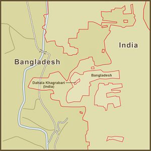 But none of these exclaves, enclaves or counter-enclaves quite compares to the situation with Dahala Khagrabari, historically the most complexly nested enclave in the world. In this case, there was a piece of India inside a piece of Bangladesh inside a piece of India inside of Bangladesh — the only known third-order enclave in history.
The modest, two-acre parcel at the center of this mess was owned by a Bangladeshi farmer who would wake up in Bangladesh and cross into India to farm his land. This record-setting enclave was eliminated in 2015, however, during the latest in a series of cross-border land swaps between the two countries. Residents were given the choice to stay in place or move “back” across the border into their “home” country.


Comments (20)
Share
can you link to inception island?
Where is Inception Island?
I just got Google Maps to approve a geotag for Inception Island!
https://www.google.com/maps/place/Inception+Island/@69.7924795,-108.2432585,16.5z/data=!4m5!3m4!1s0x5191f341dbb780f1:0x7e4d0e9c9f107f1a!8m2!3d69.7924404!4d-108.2410965?hl=en-US
The discussion of graffiti on trip points made me think of the Cofiwch Dryweryn phenomenon. It’s a slogan meaning ‘Remember Tryweryn’ that started appearing all over wales (on Trig Points and elsewhere) as a low key Welsh nationalist movement, recalling the flooding of a Welsh valley to provide water largely for English towns. It began in the 1960s, but is still quite a common phenomenon. Might be an interesting subject for a show some time.
Link to Lauren’s work?
HI, can you please post a picture of the location of “inception Island” ????
As a long time Ingress player, 99pi has been something of an inspiration (I once used the “always read the plaque” shirt as neutral camouflage during a large scale Ingress battle, where participants often wear faction colors!)
Since you’re in Oakland, you should probably visit Niantic’s offices in SF (you probably already know what the company name is from…)
A show about Ingress itself would be worthwhile. It draws thousands of players worldwide to special events and is played daily by many more. A good time to meet some is every first Saturday of the month, when there is an official gathering in cities all over the world.
Great episode as usual. It reminded me of my childhood: I used to go to summer camp on Star island in Cass Lake in northern Minnesota (Unistar!!) – I have no way to verify this but the camp used to say the lake located on the island, Lake Windigo, was the largest lake on an island on a lake in the US. Cass Lake is also just downstream from and was once named the head waters for the Mississippi River. A beautiful place to visit in spite of the millions of mayflies that descend on the lake in early summer.
There is another inception island in the Philippines.
– Vulcan Point Island is inside…
– Crater Lake which is inside…
– The Taal volcano and happens to be an island inside…
– Taal Lake which is inside…
– Luzon Island, the largest island in the Philippines.
Vulcan Point Island
San Nicolas, Philippines
https://maps.app.goo.gl/cVbsap1scm2CPM1D7
This Pokemon song is so awesome :)
Ah, i wanted to know: what’s the title? I don’t remember it from the first game.
I have to admit, that I had a fleeting hope that one of the stories in this episode would be about people who draw their own maps and invent their own worlds for their writing or for D&D. Even with the limited exposure that I’ve achieved, it blows me away the lengths that some people go to to invent constructed languages or fictional worlds detailed down to the plate tectonics.
All the same, my own efforts in the future will go a little further to include enclaves and exclaves as well as triangulation stations in my made up maps.
Very good pod, Kurt. To the quirks of the enclaves and exclaves, I would add Bir Tarwil – the place in the middle east that is not in any country ! https://www.sporcle.com/blog/2017/09/a-history-of-bir-tawil/
I have always been fascinated by the pieces of states that are separated from their home state by the meandering history of the Mississippi River (and other rivers, I’m sure). Look closely at a Google map of Arkansas’ southeastern border, as just one example. Pieces of Arkansas are now on the Mississippi State side of the river, and vice versa. When this happens, do states ever renegotiate their boundaries?
What about Ryan Island mentioned on NPR the other day? They said it was the largest island in the largest lake on the largest island in the largest lake in the world. https://goo.gl/maps/7Uo2V6GfFVEudSZ37
When you first mentioned the “Inception Island” in Canada I thought you were talking about the one in Newfoundland!
https://goo.gl/maps/owCsdczTuUaiGmQG6
Great episode as always!
“They were fairly sure where Greenwich observatory was” (approx quote. Longitude is defined by Greenwich observatory!!!!
Would love to hear a Part 2 on the bits of soil designated as foreign territory for political reasons: e.g. embassies, military cemeteries, and this tiny piece of Holland I’ve always been charmed by:
https://www.canadiangeographic.ca/article/ottawa-maternity-ward-became-international-territory-birth-royal
Another great episode. Obviously, I’m a few months behind.
To add to the Inception Island theme, here is a trivia question from my backpacking days: What is the largest island, on the largest lake, on the largest island, on the largest freshwater lake in the world?
Ryan island: https://www.google.com/maps/place/Ryan+Island/@48.0098966,-88.7796652,15z/data=!3m1!4b1!4m5!3m4!1s0x4d598399fadfc645:0x5b3f085da13b222d!8m2!3d48.0098831!4d-88.7709104
When it comes to exclaves, Steinstücken should be mentioned. An exclave of West Berlin, which itself was an exclave in the GDR. Funny how after many years of negotiation pieces of land were traded so a connection between the two could be built. And what implications a bridge would bring with it.
https://en.wikipedia.org/wiki/Steinst%C3%BCcken?wprov=sfla1